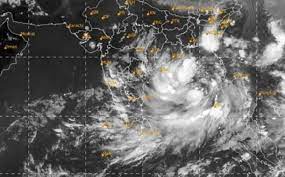
According to the National Weather Forecasting Centre of the India Meteorological Department (IMD): (TIME OF ISSUE: 1215 HOURS IST, DATED: 25.05.2021)
The Severe Cyclonic Storm ‘Yaas’ (pronounced as ‘Yass’) over westcentral and adjoining eastcentral & north Bay of Bengal– (Cyclone Warning for Odisha – West Bengal coasts-Orange Message).
The Severe Cyclonic Storm ‘Yaas’ (pronounced as ‘Yass’) over Eastcentral & adjoining Westcentral Bay of Bengal moved northwestwards with a speed of about 17 kmph during past 6 hours, and lay centred at 0830 hrs IST of today, the 25th May, 2021 over Westcentral and adjoining Eastcentral & north Bay of Bengal near latitude 18.3°N and longitude 88.3°E, about 280 km south-southeast of Paradip (Odisha), 380 km south-southeast of Balasore (Odisha), 370 km south-southeast of Digha (West Bengal) and 370 kms south-southwest of Sagar Islands (West Bengal).
It is very likely to move north-northwestwards, intensify further into a Very Severe Cyclonic Storm during next 12 hours. It would continue to move north-northwestwards, intensify further and reach Northwest Bay of Bengal near north Odisha and West Bengal coasts very close to Chandbali-Dhamra port by the early morning of Wednesday, the 26th May. It is very likely to cross north Odisha-West Bengal coasts between Paradip and Sagar Island close to north of Dhamra and south of Balasore, during noon of Wednesday, the 26th May as a Very Severe Cyclonic Storm.
Forecast track and intensity are given in the following table:
| Date/Time(IST) | Position(Lat. 0N/ long. 0E) | Maximum sustained surface wind speed (Kmph) | Category of cyclonic disturbance |
| 25.05.21/0830 | 18.3/88.3 | 100-110 gusting to 120 | Severe Cyclonic Storm |
| 25.05.21/1130 | 18.7/88.0 | 105-115 gusting to 125 | Severe Cyclonic Storm |
| 25.05.21/1730 | 19.5/87.8 | 125-135 gusting to 150 | Very Severe Cyclonic Storm |
| 25.05.21/2330 | 20.1/87.6 | 145-155 gusting to 170 | Very Severe Cyclonic Storm |
| 26.05.21/0530 | 20.7/87.3 | 155-165 gusting to 185 | Very Severe Cyclonic Storm |
| 26.05.21/1730 | 21.8/86.3 | 115-125 gusting to 140 | Very Severe Cyclonic Storm |
| 27.05.21/0530 | 22.5/85.6 | 60-70 gusting to 80 | Cyclonic Storm |
| 27.05.21/1730 | 23.2/84.7 | 35-45 gusting to 55 | Depression |
Warnings:(i)
Rainfall: North Coastal Andhra Pradesh: Light to moderate rainfall at many places with heavy to very heavy falls at isolated places on 25th May.
Odisha: Light to moderate rainfall at many places with heavy to very heavy rainfall and extremely heavy rainfall in Jagatsinghpur, Kendrapara, Bhadrak, Balasore districts, heavy to very heavy rainfall over Puri, Khurda, Cuttack, Jajpur, Mayurbhanj and heavy over Ganjam, Dhenkanal, Keonjhargarh districts on 25th, heavy to very heavy rains at a few places with extremely heavy falls at isolated places in Jagatsinghpur, Kendrapara, Jajpur, Bhadrak, Balasore, Mayurbhanj, Cuttack, Dhenkanal, Keonjhargarh and heavy falls at isolated places in Puri, Khurda, Angul, Deogarh, Sundergarh on 26th May and heavy falls at isolated places in north interior Odisha on 27th May.
West Bengal: Light to moderate rainfall at most places with heavy to very heavy rainfall over Medinipur, South 24 Parganas and heavy rainfall at isolated places in Howrah, Hooghly,Kolkata & north 24 Parganas districts on 25th, extremely heavy rainfall at isolated places over Medinipur and heavy to very heavy rainfall at isolated places over Jhargram, Bankura, south 24 Parganas and heavy falls at isolated places over Purulia, Nadia, Murshidabad, east Bardhaman, Howrah, Hooghly, Kolkata, north 24 Parganas, Haldia, Darjeeling, Kalimpong Districts on 26th May and heavy rain at isolated places in Jhargram, west Medinipur, Bankura, Purulia, west Bardhaman, Bhirbhum, Malda, Darjeeling, Kalimpong, Jalpaiguri on 27th May.
Jharkhand: Light to moderate rainfall at most places with heavy rainfall at isolated places on 25th May, heavy to very heavy rainfall and extremely heavy falls at isolated places on 26th & 27th May.
Bihar: Light to moderate rainfall at most places with heavy to very heavy rainfall and extremely heavy falls at isolated places on 27th May and isolated heavy to very heavy falls on 28th May.
Assam & Meghalaya: Light to moderate rainfall at most places with heavy to very heavy rainfall at isolated places on 25th & 26th May.
(ii) Wind warning:· Gale winds speed reaching 100-110 kmph gusting to 120 kmph is prevailing over major parts of central Bay of Bengal and adjoining north Bay of Bengal and would increase gradually becoming 125-135 gusting to 140 kmph from today evening. · Squally wind speed reaching 55-65 kmph gusting 75 kmph is prevailing over North Bay of Bengal and along and off north Andhra Pradesh-Odisha–West Bengal–Bangladesh coasts. It would further increase becoming 65-75 kmph gusting to 85 kmph over northwest Bay of Bengal and along & off north Odisha and adjoining West Bengal coasts including Jagatsinghpur, Kendrapara, Puri, Bhadrak, Balasore of Odisha and east Medinipur, south 24 Parganas, Kolkata districts of West Bengal from 25th May evening. Squally wind speed reaching 40-50 kmph gusting 60 kmph would prevail over Ganjam, Khurda, Cuttack, Jajpur & Mayurbhanj Districts of Odisha and Howrah, Hooghly, north 24 Parganas Districts of West Bengal from 25th evening.· It would further increase becoming gale wind speed 155-165 kmph gusting to 185 kmph over northwest Bay of Bengal and along & off north Odisha and adjoining West Bengal coasts including Jagatsinghpur, Kendrapara, Bhadrak, from early morning of 26th May and will extend to Balasore district of Odisha from the forenoon of 26th May, 120-130 kmph gusting to 145 kmph over Mayurbhanj district of Odisha from early morning of 26th May. Gale wind speed reaching 80-90 kmph gusting to 100 kmph would prevail over Puri, Cuttack, Khurda, Jajpur and Nayagarh districts of Odisha during same period. The wind speed reaching 60-80 kmph gusting to 90 kmph would prevail along and off Ganjam and remaining interior districts of north Odisha· Squally wind speed reaching 60-80 kmph gusting to 90 kmph would prevail over Ganjam, Dhenkanal and Keonjhar districts of Odisha and Bankura, Purulia, Howrah, Hooghly, Nadia & Burdhaman districts of Wet Bengal from 26th early hours. Squally wind speed reaching 50-60 kmph gusting to 70 kmph would prevail over Angul, Deogarh & Sundergarh districts of Odisha, Birbhum & Murshidabad districts of West Bengal and Srikakulam, Vijayanagaram & Vishakhapatnam districts of Andhra Pradesh during same period.· 40-50 kmph gusting 60 kmph is very likely to prevail over south Jharkhand from 26th forenoon and increase gradually becoming 90-120 kmph gusting to 130 kmph over southeast Jharkhand and 70-80 kmph gusting to 90 kmph over southwest Jharkhand during 26th evening / night.· Squally wind speed reaching 50-65 kmph gusting to 70 kmph would prevail over Kendrapara, Bhadrak, Balasore, Keonjhargarh, Mayurbhanj, Deogarh, Sundergarh Districts of Odisha and west Medinipur, Jhargram, Bankura, Purulia Districts of West Bengal on 27th.
(iii) Sea condition· Sea condition is High to Very High over Westcentral and adjoining eastcentral & north Bay of Bengal. It is very likely to become Very High to Phenomenal over northern parts of central Bay of Bengal, north Bay of Bengal and along & off north Andhra Pradesh-Odisha–West Bengal-Bangladesh coasts during 25th evening to 26th May evening.
(iv) Fishermen Warning· The fishermen are advised not to venture into central Bay of Bengal till 26th May forenoon and into north Bay of Bengal and along & off north Andhra Pradesh-Odisha-West Bengal–Bangladesh coasts during 25th – 26th May.
(v) Storm surge warning. Tidal waves of height 2-4 meters above astronomical tide are likely to inundate low lying low laying areas of Medinipur, Balasore, Bhadrak and about 2 meters above astronomical tide are likely to inundate low lying low laying areas of South 24 Parganas, Kendrapara & Jagatsinghpur Districts around the time of landfall.
Damage Expected for coastal districts of North Odisha, West Bengal and adjoining interior districts of these states:
- Total destruction of thatched houses/ extensive damage to kutcha houses. Some damage to pucca houses.
- Potential threat from flying objects.
- Bending/ uprooting of power and communication poles.
- Major damage to Kutcha and and Pucca roads.
- Flooding of escape routes.
- Disruption of railways, overhead power lines and signalling systems.
- Widespread damage to standing crops, plantations, orchards, falling of green coconuts and tearing of palm fronds.
- Blowing down of bushy trees like mango.
- Small boats, country crafts may get detached from moorings.
- Visibility severely affected
Action Suggested for coastal districts of North Odisha, West Bengal and adjoining interior districts of these states:
- Suspension of fishing operation and movement of ships in disturbed areas.
- Ports along the east coast of India may take necessary pre-cautions.
- Naval base operations may maintain necessary pre-cautions
- Tourism activities may be restricted over these areas.
- Mobilise evacuation from coastal areas of West Bengal & North Odisha.
- Judicious regulation of rail and road traffic.
- People in affected areas to remain indoors.
- Preparatory action before the cyclones
(Please CLICK HERE for details in graphics)
Source:PIB
visit at: www.shree1news.com



 Finance