


 Finance
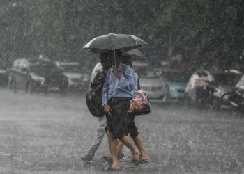
The southwest monsoon is expected to move into Odisha in the next two to three days, according to the India Meteorological Department (IMD), which has issued an orange warning for thunderstorms and strong winds in many districts of the state.
According to the Meteorological Centre of Bhubaneswar’s lunchtime weather advisory, the southwest monsoon has moved into more parts of Karnataka, Telangana, Andhra Pradesh, West Bengal, and Bihar. The IMD stated that meteorological conditions are now favorable for its further approach into areas of Odisha during the next 48 to 72 hours.
Light to heavy rainfall and thunderstorms were reported in isolated areas in Odisha over the last 24 hours.
Rairakhol in Sambalpur district, Pottangi in Koraput, and Nilgiri in Balasore district received the most rainfall at 3 cm each. Several locations in Koraput, Rayagada, Nabarangpur, and Kandhamal districts also had moderate rainfall.
The IMD has issued an orange warning for Friday, predicting thunderstorms with lightning and gusty surface winds of 50-60 kmph at isolated locations in Balasore, Bhadrak, Jajpur, Kendrapara, Jagatsinghpur, Cuttack, Sundargarh, Angul, Dhenkanal, Keonjhar, Mayurbhanj, Nabarangpur, Rayagada, Koraput, Malkangiri, Puri, Khurda, and Nayagarh districts.
A yellow alert has been issued for the remaining districts, where thunderstorms with winds of 40-50 kmph are expected. Hot and humid weather conditions may also exist in isolated areas throughout many coastal districts.
The IMD has expected extensive rains and thunderstorms across the state from June 12 to 13. Heavy rains, thunderstorms, and strong winds are expected in isolated areas in Kendrapara, Cuttack, Mayurbhanj, Koraput, and Malkangiri districts, prompting another orange alert.
Heavy rainfall is expected in northern and southern Odisha between June 13 and June 16, notably in the districts of Keonjhar, Mayurbhanj, Kandhamal, Rayagada, Koraput, Malkangiri, and Gajapati.
The IMD warned that severe winds could harm standing crops, banana plantations, electricity and communication lines, and vulnerable structures. During periods of heavy rain, there is a risk of localized flooding, waterlogging in low-lying urban areas, and traffic interruption.
Meanwhile, temperatures varied throughout the state. Bolangir recorded the highest maximum temperature of 41 degrees Celsius, while Koraput had the lowest minimum temperature of 20.8 degrees Celsius. The IMD predicts no notable change in daytime temperatures for the next 24 hours, followed by a steady drop of 2-4 degrees Celsius during the next six days.
The IMD has projected a partly overcast sky with the risk of showers or thunderstorms in Bhubaneswar and the surrounding areas over the next 24 hours. The highest and minimum temperatures are predicted to be around 39 and 29 degrees Celsius, respectively.


